Common menu bar links
(Note: Content area on this page may be wider than usual.)
 View the most recent version.
Archived Content
Information identified as archived is provided for reference, research or recordkeeping purposes. It is not subject to the Government of Canada Web Standards and has not been altered or updated since it was archived. Please contact us to request a format other than those available.
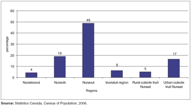
Figure 3
Distribution of the Inuit population, regions, 2006

Sources: Statistics Canada, Census of Population, 2006.
Description
This is a vertical bar chart that illustrates the distribution of the Inuit population over regions.
The Y axis is measured in percentages and increases in increments of ten from 0 to 60.
The X axis is divided into six regions. The X axis lists the following regions from left to right: Nunatsiavut, Nunavik, Nunavut, Inuvialuit region, rural outside Inuit Nunaat, and urban outside Inuit Nunaat.
4% of the total Inuit population live in Nunatsiavut.
19% of the total Inuit population live in Nunavik.
49% of the total Inuit population live in Nunavut.
6% of the total Inuit population live in the Inuvialuit region.
5% of the total Inuit population live in rural areas outside Inuit Nunaat.
17% of the total Inuit population live in urban areas outside Inuit Nunaat.
Sources: Statistics Canada, Census of Population, 2006.
