
Dictionary, Census of Population, 2016
Statistical Area Classification (SAC)
Definition
The Statistical Area Classification (SAC) groups census subdivisions (CSD) according to whether they are a component of a census metropolitan area (CMA), a census agglomeration (CA) or a census metropolitan influenced zone (MIZ). The MIZ categorizes all CSDs in provinces and territories that are outside CMAs and CAs. CSDs within provinces that are outside CMAs and CAs are assigned to one of four categories according to the degree of influence (strong, moderate, weak or no influence) that the CMAs or CAs have on them. CSDs within the territories that are outside CAs are assigned to a separate category.
The SAC is a variant of the Standard Geographical Classification (SGC). CSDs form the lowest level of the classification variant. The next level consists of CMAs, CAs and MIZs including the territories. The highest level consists of two categories that cover all of the land mass of Canada:
- inside census metropolitan areas and census agglomerations
- outside census metropolitan areas and census agglomerations.
The SAC provides unique numeric identification (codes) for these hierarchically-related geographic areas. It was established for the purpose of reporting statistics.
Reported in
2016, 2011, 2006, 2001
Remarks
In using the Statistical Area Classification (SAC) for census data tabulations, it is possible to sum census data automatically for census subdivisions (CSDs) as follows:
- all CSDs in census metropolitan areas (CMAs)
- all CSDs in census agglomerations (CAs) with census tracts
- all CSDs in census agglomerations (CAs) having no census tracts
- all CSDs in the provinces in the strong metropolitan influenced zone category
- all CSDs in the provinces in the moderate metropolitan influenced zone category
- all CSDs in the provinces in the weak metropolitan influenced zone category
- all CSDs in the provinces in the no metropolitan influenced zone category
- CSDs in the three territories (Yukon, Northwest Territories and Nunavut), except those that are components of a CA (currently the CAs of Whitehorse and Yellowknife).
Care should be exercised when applying the MIZ concept in the three territories. As many CSDs in the territories are very large and sparsely populated, the commuting flow of the resident employed labour force is unstable. For this reason, the CSDs in the territories that are outside CAs are assigned to a territories category that is not based on their commuting flows.
Figure 1.3 shows the hierarchical structure of the SAC.
Figure 1.3
Statistical Area Classification (SAC) hierarchy
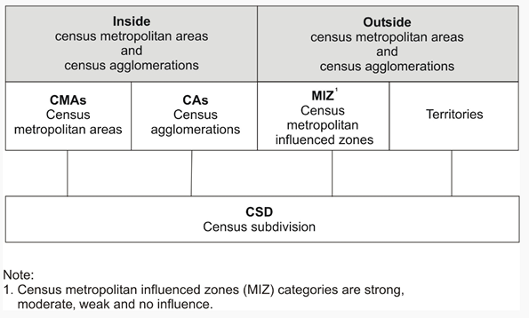
Description of Figure 1.3
Figure 1.3 is a graphical representation of the hierarchy of geographic areas that make up the Statistical Area Classification (SAC). The top level of the hierarchy appears as a pair of grey boxes positioned side by side. The box on the left is labelled 'Inside census metropolitan areas and census agglomerations' and the box on the right is labelled 'Outside census metropolitan areas and census agglomerations.'
Below the grey box on the left (Inside census metropolitan areas and census agglomerations) are two white boxes positioned side-by-side which represent the next level down in the hierarchy. The box on the left is labelled 'CMAs Census metropolitan areas' and the box on the right is labelled 'CAs Census agglomerations.'
Below the grey box on the right (Outside census metropolitan areas and census agglomerations) are two white boxes positioned side-by-side which also represent the next level down in the hierarchy. These white boxes are the equivalent level as those described in the preceding paragraph (CMAs and CAs). The box on the left is labelled 'MIZ Census metropolitan influenced zones' and the box on the right is labelled 'Territories.' The acronym MIZ (census metropolitan influenced zones) is footnoted with 'Census metropolitan influenced zones (MIZ) categories are strong, moderate, weak and no influence.'
Below the four white boxes described above is one box that represents the lowest level in the SAC hierarchy. It is labelled 'CSD Census subdivision' and is linked to each of the four white boxes above it with a single line for each white box.
Source: Statistics Canada, 2016 Census of Population.
Table 1.3 Number of census subdivisions by the Statistical Area Classification (SAC), 2016 Census
Refer to the related definitions of census metropolitan area (CMA) and census agglomeration (CA); census metropolitan influenced zone (MIZ); census subdivision (CSD); core, fringe and rural area.
Changes prior to the current census
Not applicable
- Date modified: