
Archived Content
Information identified as archived is provided for reference, research or recordkeeping purposes. It is not subject to the Government of Canada Web Standards and has not been altered or updated since it was archived. Please contact us to request a format other than those available.
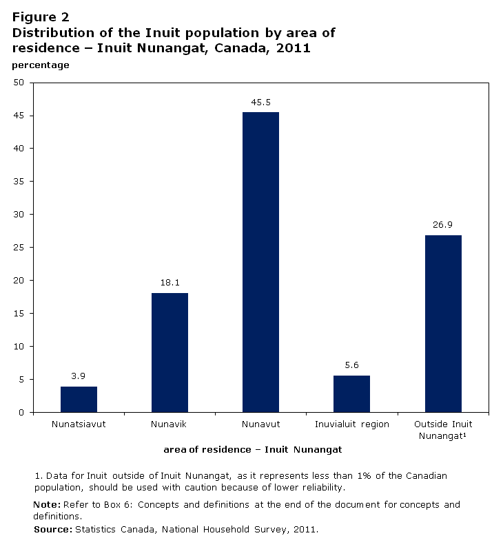
Figure 2
Distribution of the Inuit population by area of residence – Inuit Nunangat, Canada, 2011
Description for figure 2
The title of the graph is "Figure 2 Distribution of the Inuit population by area of residence – Inuit Nunangat, Canada, 2011."
This is a column clustered chart.
There are in total 5 categories in the horizontal axis. The vertical axis starts at 0 and ends at 50 with ticks every 5 points.
There are 1 series in this graph.
The vertical axis is "percentage."
The horizontal axis is "area of residence – Inuit Nunangat."
The minimum value is 3.9 and it corresponds to "Nunatsiavut."
The maximum value is 45.5 and it corresponds to "Nunavut."
| Area of residence - Inuit Nunangat | Distribution of the Inuit population (percentage) |
|---|---|
| Nunatsiavut | 3.9 |
| Nunavik | 18.1 |
| Nunavut | 45.5 |
| Inuvialuit region | 5.6 |
| Outside Inuit NunangatFootnote 1 | 26.9 |
Note: Refer to Box 6: Concepts and definitions at the end of the document for concepts and definitions.
Source: Statistics Canada, National Household Survey, 2011.
- Date modified: