
Dictionary, Census of Population, 2016
Map projection
Definition
A map projection is the mathematical formula used in the process of transforming positions from the earth's three-dimensional curved surface to a two-dimensional flat surface. The positions on the earth are defined using spherical coordinates of latitude and longitude, usually given in degrees. On a map, the positions may still be defined by spherical coordinates, or by linear coordinates, usually given in metres.
Reported in
2016, 2011, 2006, 2001, 1996, 1991, 1986, 1981, 1976 (Lambert conformal conic)
1996, 1991, 1986, 1981, 1976, 1971 (transverse Mercator)
Remarks
The earth's surface cannot be flattened without distorting geometrical properties, such as area, shape, distance and direction. These properties can be preserved individually (at least locally) and in certain combinations on map projections. However, the four basic properties of area, shape, distance and direction cannot all be held true simultaneously. Therefore, it is important to select a projection having the properties that are suited to the mapping situation. For example, a projection that accurately represents the shapes of the continents (called a conformal projection) will distort their relative sizes.
The Lambert conformal conic map projection is widely used for general maps of Canada at small scales and is the most common map projection used at Statistics Canada. The Lambert conformal conic projection (Figure 1.14) provides good directional and shape relationships for mid-latitude regions having a mainly east-to-west extent. Standard parallels at 49° N and 77° N are most commonly used. The scale is correct along the standard parallels only; areal deformation decreases between and increases away from the standard parallels. The central meridian, normally at 91° 52' W, is a straight line about which the projection is symmetrical. False eastings and northings are added to coordinate values to ensure positive values in linear units of measure (metres).
Figure 1.14
Example of a map projection and unprojected coordinates
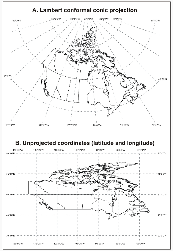
Description of Figure 1.14
Figure 1.14 shows two representations of Canada's provincial and territorial boundaries. The map on the top (A) shows an illustration of Canada as it appears when projected using the Lambert conformal conic projection. The Lambert projection provides a reasonably good relationship between the shape of and distances on Canada's land mass.
The map on the bottom (B) is the geographic projection showing latitude and longitude coordinates.
This map distorts the graphical representation of Canada's land mass such that the provincial and territorial boundaries appear much more vertical and elongated than with the Lambert projection.
Source: Statistics Canada, 2016 Census of Population.
A map which treats the spherical coordinates of latitude and longitude as linear values, by displaying them on a grid is an equirectangular map projection, also called the geographical projection. Such maps are not very useful for display as they do not preserve the spatial properties of area, shape, distance or direction. However, data in this format is easy to transfer, and then transform into a more useful projection. For a comparison of the Lambert conformal conic and geographic projections, see Figure 1.14.
The Lambert conformal conic map projection is the working projection for cartographic boundary files, digital boundary files, road network files and the Spatial Data Infrastructure, and for generating representative points. For calculating land area, the working projection is Albers equal area.
Refer to related definitions of cartographic boundary files (CBFs); coordinate system; datum; digital boundary files (DBFs); representative point; road network file (RNF) and Spatial Data Infrastructure (SDI).
Changes prior to the current census
Prior to 2001, street network files were based on the transverse Mercator map projection/Universal Transverse Mercator (UTM) coordinate system.
- Date modified: